Newfoundland Part 2: Gros Morne National Park

September 3rd - 13th
As amazing as the East coast of Newfoundland was, there was still plenty more to see and experience on the West coast - namely, the incredible Gros Morne National Park.
Neither of us knew much about Gros Morne before we got to Newfoundland. We knew it was a National Park and a UNESCO World Heritage Site, and figured it would have to have some cool hikes. And we knew that it was the site of some pretty spectacular fjords (similar, but even more majestic than what we saw in Saguenay, Quebec). But gosh, what we weren't expecting was for the whole park to be so fascinating. Or that the fjords wouldn't even be the star attraction. Or that rocks - yes, rocks - could be so interesting.
But first, we had to get ourselves from the east side of the island to the west.
Gander
After leaving Terra Nova National Park, we had set ourselves the goal of driving West across the island and arriving in Gros Morne in time to get to the Discovery Centre before it closed at 5pm. With only a limited number of days left on the Rock, we need to maximize our activity levels!
But that didn't mean we couldn't make time to stop at Gander on the way across. Gander, you may recall, is the setting for Canada's Best Musical (with apologies to Anne of Green Gables) - Come From Away. The play recounts the story of the 38 planes and 7000+ passengers that descended on Gander following the 9/11 attacks. If you haven't seen it yet, do yourself a favour... you'll laugh, you'll cry, you'll want to come to Newfoundland and get Screeched In. (Like us!)
.jpg)
 |
| A girder from the World Trade Center |

The airport also has quite a famous airport lounge (believe it or not). Back in the days before planes could fly very far (and before airport security was a thing), Gander was an important refueling stop for international flights from Europe. Very Famous People regularly came through the airport, and the Gander locals (Ganderites? Ganderians? Ganderlions?) would regularly wander down to the airport to rub shoulders with royalty, as it were. By the 50's the Canadian government realized that a giant ratty old hangar was probably not the best introduction to Canada for these international guests - especially when Gander had become one of the busiest international airports in the world. So, they kitted out a new airport including a futuristic lounge with furniture from some up-and-coming names and a giant mural across the main wall.


They also installed a futuristic helicopter game, which is still there!
We spent about half an hour wandering around (playing the helicopter game) before heading back on the highway.
Four hours later, we pulled into our first Airbnb in Gros Morne.
Gros Morne National Park (Southern End)
We had about a week set aside to explore Gros Morne National Park. We started out at the Southern end, staying in a cute little town (hamlet?) called Birchy Head. There were three or four hikes we definitely had earmarked in this end of the park, but our first stop after dropping our bags off was the Discovery Centre, to speak to the staff there and get the lowdown on how best to tackle the area. This strategy immediately paid off, as the lovely and tres enthousiaste park employee told us about a couple of 'off trail' hikes that we wouldn't have found out about otherwise.
With a couple of hours of daylight left, and the following day's weather looking a little questionable, we decided to head up the Lookout Trail directly above the Discovery Centre. The trail promised a vista of the main attractions at this end of the park, helping us to orient ourselves for our activities over the next few days.
The first section was short but steep, before opening up to a more gentle rise to the peak. The requisite Muskoka chairs at the top telegraphed 'Take Photos Here' extremely clearly - and that we did.

To our left, we could see across Bonne Bay to the Northern end of the park, where Gros Morne Mountain loomed over Norris Point.

It's the grey-coloured, flat-topped mountain on the right side of the photo. Although it's only about 15km away from where we're standing, it's over an hour's drive away on the 'north' side of the park. So we'll be saving that hike for when we move up there later in the week.
To our right we could clearly see the part of the park called the Tablelands. It's easy to see where the name of this area came from, with its freakishly flat top.

But it's not its shape that makes Tablelands so special. Terms like 'bizarre' and 'otherworldly' are regularly used to describe this landscape, and the Discovery Centre does an amazing job of describing the phenomenon that created this part of the Long Range mountain range, and why it was declared a UNESCO World Heritage Site. We'll try and do it justice, but really, you should come and check it out yourself...
Tablelands Off-Trail Loop
What you immediately notice about the Tablelands is how different they are from the other mountains around them. They are stark, largely devoid of vegetation, and have a reddish hue which many have compared to the surface of Mars. Even on Google Maps you can quickly see that they are completely unlike anything around them:

It was this uniqueness that drew Hank Williams, a Canadian geologist, to study the geological makeup of the Tablelands back in the late 60's. His PhD supervisor, John Tuzo Wilson, had famously published a paper in 1966 that made some bold assertions about the formation and later destruction of an ancient ocean, the Iapetus.
The paper laid out the theory of plate tectonics which, although accepted today, at the time was controversial at best and quackery at worst, especially as the evidence to prove the theory had not yet been discovered. It was Williams' work at the Tablelands which provided this evidence, by demonstrating that the rocks making up the terrain here were in fact ancient (500+ million years old) exposed parts of the earth's mantle, an extremely rare phenomenon caused by one tectonic plate 'bulldozing' the surface of another plate as they were pushed together. This provided the proof for Wilson's Plate Tectonics theory, and led to Gros Morne being recognized as a UNESCO site in 1987. It continues to bring scientists to the area to study its unique geology.
And, it offers a spectacular and extremely challenging hike. It's called the 'Off trail loop', with a heavy emphasis on 'off trail' - in fact it should probably be called 'No trail loop'. It's a 14km round trip and took us about 7 hours to complete.
We started our hike by tagging along with the National Park's daily guided walk along the main trail. The guide gave us all sorts of useful intel about the formation of the park, as well as the (lack of) flora and fauna, and the rockology of the place.
Here's a rock:

And a plant:

Enough of that. We left the main group of oldies and retirees (like us, I suppose) and headed off for the beginning of the Off Trail Loop, which starts off innocently enough with a steep but straightforward hike up to a waterfall.


.jpg)
From there, the fun begins. Scree gives way to large boulders and it gets steeper still.


Boulders as far as the eye can see. These rocks are called peridotites, and are from the mantle of the earth. They lack the nutrients to support most plant life, hence the barren nature of the Tablelands. The brownish colour is from the iron within the rocks.

It was a hard scramble for most of the hike, and required a high degree of concentration not to break an ankle! But the views were absolutely stunning. Al's #1 hike of the trip.


 |
| Sandwich cam |
Again, the photos don't even come close to capturing the experience! This was one of the best things we did on our trip (so far :-)).
And as we mentioned, the Discovery Centre does an incredible job of presenting this material in an easy-to-understand and fascinating way. (Waaay better than the job we do here).
Green Gardens Trail
The next day we drove down the coast to another famous hike in the park, the Green Gardens Trail. While it couldn't compare to the previous day, it was still a beautiful hike in its own right.

These rocks are a more 'traditional' example of the mantle being exposed to us humans up here. They were formed when an underwater fissure was spitting out globules of magma (say it with me: Mag-ma) which formed these telltale sphere shapes. The ocean later retreated, leaving the globs behind.


Also, sheep.

To the North end of the park
The following day we packed up and made the trek around the inlet to the Northern side of the park. It's about an hour's drive around, taking you out of the park and back in.
Despite plenty of promises, we never did see any moose on the island. But they do have these cool signs.
.jpg)
The weather was a little drizzly that day, meaning we would have to wait for a clearer day to summit Gros Morne Mountain. In the meantime, we did a short coastal walk along the shoreline, out to Green Point.

The juniper forests along the way were truly amazing - straight out of the The Hobbit!


Gros Morne Mountain
The following morning the weather was clear, meaning we had a good chance of being able to reach the summit of Gros Morne Mountain. Having had this beastie looming over us since our arrival, we were looking forward to seeing the views from the top.

The view from the trailhead is a little daunting - how in the world do you make your way up this thing? It's so... steep looking...


Yes... yes, it is...

.jpg)

Here's a view from about halfway up, with the Tablelands visible in the distance

The views from the top were worth the climb.


.jpg)


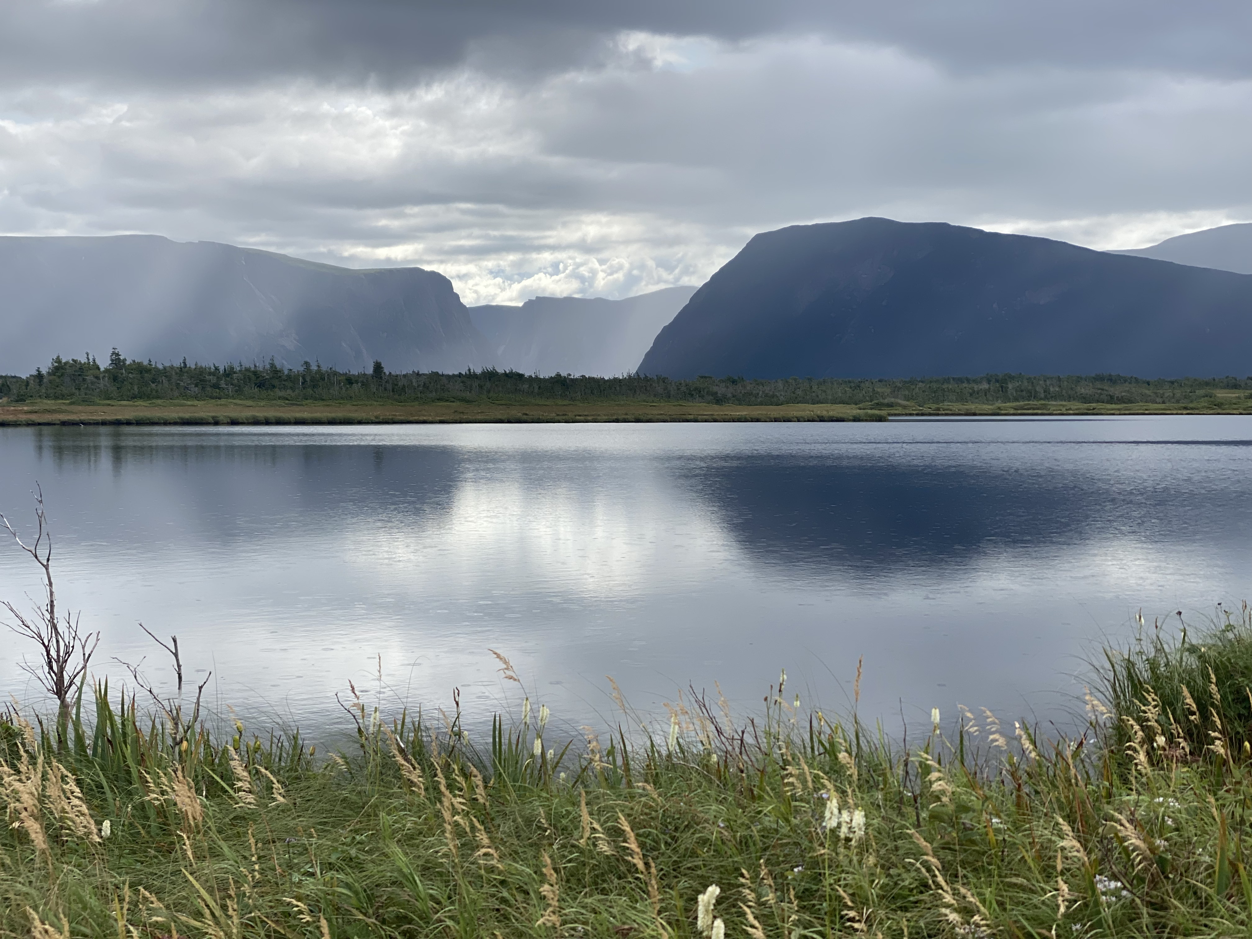
The Fjord at Western Brook Pond
The final 'bucket list' item on the Gros Morne agenda was the boat ride through the Western Brook Pond fjord. The view from the end of the fjord is one of the most photographed in the park (though a little higher than our vantage point on the boat. We couldn't justify spending $300 per person to hike up for the photo op). But the boat ride was pretty spectacular!


The Wreck of the SS Ethie and Broom Point
We had another couple of days before our ferry, so we went and had a look at some of the other attractions in the area.
Unsurprisingly, there have been many shipwrecks along the coast of Newfoundland. The SS Ethie was caught in a violent storm in December 1919, and the captain intentionally ran her aground to rescue the passengers and crew. A baby was sent ashore in a mailbag! The wreckage is still here on the beach.
.jpg)


And, we visited Broom Point just because.


Farewell, thee Rock!
We rounded out our trip to the Rock with a round of golf. Even the golf courses have spectacular views.


And in return Newfoundland gave us one last gorgeous sunset to remember it by.


Comments
Post a Comment